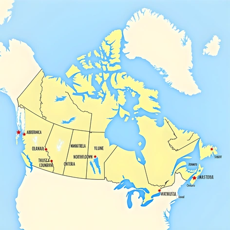
how to draw a map of canada and labeled
Resize and add details
Convert to video
Outpaint the rest of the image
Additional Info
ModelFlux
Seed164040993
Enhanced PromptMap of Canada, labeled, featuring significant geographical features, major cities, and notable landmarks, drawn in a clean, modern style, similar to Google Maps. Canada, 10 million km², vast territory, divided into ten provinces and three territories, bordering the United States to the south, the Arctic Ocean to the north, the Atlantic Ocean to the east, and the Pacific Ocean to the west. Provinces: - Quebec, largest province, stretching from the Great Lakes to the Saint Lawrence River, home to Montreal, second-largest city, French-speaking majority. - Ontario, most populous province, containing Toronto, largest city, economic hub, diverse culture. - British Columbia, westernmost province, mountainous terrain, scenic coastline, Vancouver, popular tourist destination. - Alberta, oil-rich province, Calgary, major economic center, Banff National Park, stunning natural beauty. - Saskatchewan, agricultural heartland, Regina, capital city, prairie landscapes, vast open spaces. - Manitoba, Hudson Bay shoreline, Winnipeg, capital city, fertile soil, rich history. - Nova Scotia, Maritime province, Halifax, major port city, coastal scenery, strong fishing industry. - New Brunswick, mixed forests, Saint John, historic city, Acadian heritage, cultural significance. - Prince Edward Island, smallest province, Charlottetown, charming capital, beaches, rolling hills, picturesque landscapes. - Newfoundland and Labrador, easternmost province, St. John's, vibrant capital, rocky coastlines, whale watching, unique culture. - Yukon, northernmost territory, Whitehorse, capital city, wildlife viewing, outdoor adventures. - Northwest Territories, vast wilderness, Yellowknife, capital city, Aurora Borealis, Northern Lights. - Nunavut, newest territory, Iqaluit, capital city, Inuit culture, Arctic wildlife. Notable landmarks: - Niagara Falls, breathtaking waterfalls, shared border crossing, international tourism. - CN Tower, Toronto, iconic skyscraper, panoramic views, engineering marvel. - Banff National Park, mountain scenery, glaciers, hot springs, abundant wildlife. - Old Quebec City, historic walled city, cobblestone streets, charming architecture. - Vancouver Island, Pacific coastline, temperate rainforests, scenic drives. - Gros Morne National Park, UNESCO site, hiking trails, fjords, rugged coastline. - Canadian Rockies, majestic mountain range, glaciers, lakes, alpine meadows. - Bay of Fundy, highest tides in world, tide-watching, kayaking, scenic boat tours. - Churchill, polar bear capital, Arctic wildlife, dog sledding, snowmobiling. - Lake Louise, turquoise lake, ski resorts, hiking trails, picturesque village. - Sault Ste. Marie, Soo Locks, ship canal, maritime history, engineering feat. - Jasper National Park, wildlife reserve, grizzly bears, wolves, elk, moose, bison. - Rideau Canal, UNESCO site, waterway connecting Ottawa to Kingston, historic locks, scenic boat cruises. - Head-Smashed-In Buffalo Jump, ancient site, prehistoric human activity, fossil discoveries. - Signal